Tamriel Rebuilt:Coronati Basin
< Mod / Morrowind: Tamriel Rebuilt: Places: Regions(Redirected from Tamriel Rebuilt:Thirr Valley)- The Thirr Valley is situated in a great canyon surrounding the Thirr River as it makes its way north. Mushroom mangroves dominate the river banks and the landscape slowly shifts from the Aanthirin's orange-green to Shipal-Shin's red. Caught in politics and business, Hlaalu villages dot the landscape, and House Redoran has its furthest outposts here, keeping a wary eye on boat travel. —Tamriel Rebuilt
| ● Coronati Basin Weather Table ● | |||||
|---|---|---|---|---|---|
| ● | Clear | 15% | ● | Thunder | 5% |
| ● | Cloudy | 45% | ● | Foggy | 10% |
| ● | Ash | 0% | ● | Blight | 0% |
| ● | Overcast | 10% | ● | Rain | 15% |
| ● | Snow | 0% | ● | Blizzard | 0% |


Coronati Basin is a region in the Narsis District of Morrowind, with a distinct yellow-orange landscape. Lake Coronati is centered in the valley, and the Thirr River flows north from its start in Narsis. The edges of Lake Coronati are shallow and choked with mangrove parasols, and the relatively rich soil on its shores provides space for a number of plantations. The soil quickly dries out and gives way to grassland further from the lake and river, however, and as it slopes upwards becomes increasingly rocky and cut by low cliffs.
Its largest settlements are Othmura and Hlerynhul. The region borders Aanthirin to the north, the Armun Ashlands to the northwest, the Othreleth Woods to the west, Shipal-Shin to the south, and the Deshaan Plains to the east.
PlacesEdit
A list of places found in the Coronati Basin region.
SettlementsEdit
Towns (Tier III)Edit
- Ald Iuval
- Othmura — A Hlaalu settlement located on a cliff, along the northern tongue of Lake Coronati.
- Hlerynhul — A riverside town just outside of Narsis, housing a few businesses and villagers. It sits on the bank of the Thirr River.
Villages (Tier IV)Edit
Hamlets (Tier VI)Edit
- Ald Marak
- Baryon Plantation
- Gro-Uthig Plantation
- Hladri Winery
- Mothran Plantation
- Sarys Plantation
- Thavas Farm — A small Corkbulb farm run by mother and son.
- Ulven Plantation
- Umalor Plantation
- Vadaryn Plantation
Outposts (Tier V)Edit
DwellingsEdit
- Andrani Farmhouse — A small guar farm in the northern Coronati Basin.
- Aren Farmhouse
- Bera Famori's Shack
- Decodorius Ranch
- Drals Farmhouse
- Gathram Farmhouse
- Iain's Tent
- Llemis Ranch
- Turesa Veldyn's Tent
- Vedralu Farmhouse
- Vedrano Farmhouse
- Yfrac Farmhouse
CavesEdit
- Atemu
- Esultin
- Han-Palit
- Iden
- Gulmebi
- Kushrendar
- Mubura
- Ninabi
- Odirnamus — A bandit cave and encampment southwest of Hlan Oek
- Sael-Hla
- Sarat-Libali
- Shamsi — A medium-sized bandit cave, west of Othmura.
- Tananta
- Ushudartus — A prospective egg mine site...according to a clueless eggminer.
- Zarathil
Daedric RuinsEdit
- Alta Vathor — A shrine to Azura north of Narsis.
- Ashishibishi
- Bessarnamidan
- Manishtashut
- Naemunbatashpi — A treasure-laden Coronati shrine to Mehrunes Dagon.
Dreugh HivesEdit
Dunmer StrongholdsEdit
- Hlorandar
- Othrano — A stronghold half-buried in a Coronati hillside.
- Vandirelyon
GrottosEdit
- Danrilk Grotto — A small grotto on the Thirr River, east of Othmura.
- Magun Grotto
- Mirhel Grotto
- Nidipal Grotto
- Para-Ad Grotto
- Tupilu Grotto
- Tusadd Grotto
- Zurindi Grotto
MinesEdit
- Ibbi-Suen Mine
- Ishal-Mul Egg Mine
- Sasamsi Egg Mine — An abandoned mine claimed by Swamp Trolls.
- Tabiash Egg Mine
Redoran RuinsEdit
ShipsEdit
TombsEdit
- Andrelo Ancestral Tomb
- Droryn Ancestral Tomb
- Drurel Ancestral Tomb
- Llaren Ancestral Tomb
- Orelu Ancestral Tomb
- Ralaal Ancestral Tomb — A small tomb teeming with undead guardians.
- Raran Ancestral Tomb — A tomb overlooking a popular pilgrim's spot.
- Sadras Ancestral Tomb
- Selroth Ancestral Tomb
- Selvilo Ancestral Tomb
- Ulven Ancestral Tomb
Velothi TowersEdit
GalleryEdit
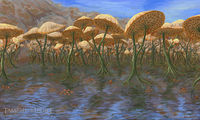
Concept art of Thirr Valley by Kaziem

NotesEdit
- This region was renamed from Thirr Valley on 2022-01-09 to better reflect the geography of the region by this point in its development.[1]
See AlsoEdit
- For more background information, see Tamriel Rebuilt's planning document for Coronati Basin.