| This place page is currently being rechecked as part of the Oblivion Remastered Project. The page is being checked in several stages to verify any changes due to the release of Oblivion Remastered. All users are welcome to make changes to the page. If you make a change that is relevant to the project, please update this template accordingly, and make sure you have observed the project guidelines. Details Walkthrough: not written Interior Remastered Images: not added |
| ● Weather Table ● | |||||
|---|---|---|---|---|---|
| ● | Clear | 35% | ● | Thunder | 5% |
| ● | Cloudy | 40% | ● | Foggy | 5% |
| ● | Overcast | 10% | ● | Rain | 5% |
| ● | Snow | 0% | |||
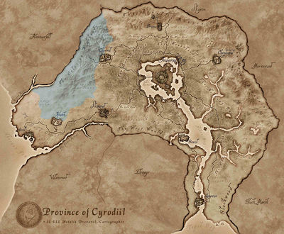
Colovian Highlands is the plateau on the western edge of Cyrodiil. The borders of Hammerfell lie to the west. The Black Road extends a short way into the region from the eastern border. The regions of Gold Coast and West Weald border on the south, and the regions of Jerall Mountains and Great Forest on the east.
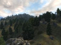
Vegetation in the region is sparse. There is a reasonable concentration of Mandrake along the border with Hammerfell, some Clouded Funnel Cap to the north, plus Motherwort and Viper's Bugloss in the southwest, but apart from those the highlands are an area of bare rock, wispy grass and light forestation.
Colovian Highlands PlacesEdit
A list of places found in the region of Colovian Highlands.
SubregionsEdit
- Imperial Reserve — The grasslands west of the Great Forest extending as far as the Gold Coast.
RoadsEdit
- Black Road — Main road from the Imperial City to Chorrol.
LandmarksEdit
- Cloud Top — A mountain and ruined fort northwest of Chorrol (quest-related). (map)
Daedric ShrinesEdit
- Shrine of Sanguine — A Daedric shrine north-northwest of Skingrad. (map)
Ayleid RuinsEdit
- Hrotanda Vale — A medium-sized Ayleid ruin north of Chorrol containing bandits. (map)
- Lipsand Tarn — A medium-sized Ayleid ruin north of Chorrol containing vampires. (map)
- Nonungalo — A medium-sized Ayleid ruin between Chorrol and Skingrad containing monsters. (map)
- Talwinque — A medium-sized Ayleid ruin between Skingrad and Kvatch containing bandits. (map)
- Trumbe — A small Ayleid ruin northwest of Kvatch containing undead. (map)
- Varondo — A medium-sized Ayleid ruin north of Kvatch containing conjurers and daedra. (map)
FortsEdit
- Battlehorn CastleFS — A large castle west of Chorrol that can be won by defeating the attacking marauders (download-specific). (map)
- Fort Dirich — A small fort between Skingrad and Chorrol containing undead (quest-related). (map)
- Fort Hastrel — A medium-sized fort north-northwest of Kvatch containing vampires. (map)
- Fort Linchal — A medium-sized fort north of Kvatch containing necromancers. (map)
- Fort Ontus — A medium-sized fort north-northeast of Kvatch containing necromancers (quest-related). (map)
- Fort Rayles — A medium-sized fort northwest of Chorrol containing conjurers. (map)
- Fort Wariel — A small fort northwest of Kvatch containing marauders. (map)
MinesEdit
- Echo Mine — A small mine northwest of Skingrad containing bandits. (map)
- Infested Mine — A medium-sized mine north of Kvatch containing marauders. (map)
- Pillaged Mine — A medium-sized mine southwest of Chorrol containing goblins. (map)
- Shattered Mine — A medium-sized mine north of Kvatch containing bandits. (map)
CavesEdit
- Black Rock Caverns — A medium-sized cave northwest of Chorrol containing bandits. (map)
- Broken Promises Cave — A small cave southwest of Chorrol containing bandits. (map)
- Mongrel's Tooth Cave — A small cave north of Kvatch containing monsters. (map)
- Nonwyll Cavern — A medium-sized cave north of Chorrol containing monsters (quest-related). (map)
- Rock Bottom Caverns — A small cave between Chorrol and Skingrad containing goblins. (map)
- Wind Cave — A medium-sized cave between Chorrol and Skingrad containing monsters. (map)
CampsitesEdit
- Brotch Camp — A campsite northwest of Skingrad containing bandits (quest-related). (map)
- Camp Ales — A campsite north of Kvatch containing bandits (quest-related). (map)
- Dagny's Camp — A campsite northeast of Kvatch containing bandits (quest-related). (map)
- Last Chance Camp — A campsite northwest of Kvatch containing bandits. (map)
- Valley View Camp — A campsite northwest of Skingrad containing bandits. (map)
Colovian Highlands QuestsEdit
A list of all quests involving the region of Colovian Highlands.
Fighters GuildEdit
- The Master's Son: The Fighters Guild has been hired to find Galtus Previa, and Viranus Donton needs a confidence boost.
Mages GuildEdit
- Fingers of the Mountain: Sort out a problem with a former guild member to obtain a recommendation from Chorrol.
- The Necromancer's Amulet: Find the Necromancer's Amulet and return it to the Arcane University.
Daedric QuestsEdit
Miscellaneous QuestsEdit
- A Venerable Vintage: Nerussa would like you to collect six bottles of a rare wine for her.
Official Plug-insEdit
OrreryEdit
- Repairing the OrreryOR: Harness the power of the stars. Rebuild the defiled Orrery and unlock the secrets of this Mages Guild Inner Sanctum.
Fighter's StrongholdEdit
- Battlehorn CastleFS: Rescue Battlehorn Castle from marauders, and claim it as your own.

