| ● Weather Table ● | |||||
|---|---|---|---|---|---|
| ● | Clear | 35% | ● | Thunder | 5% |
| ● | Cloudy | 40% | ● | Foggy | 5% |
| ● | Overcast | 10% | ● | Rain | 5% |
| ● | Snow | 0% | |||
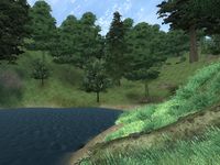
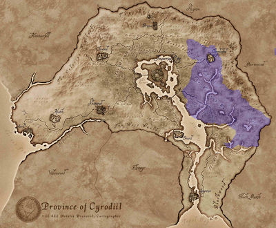
The Nibenay Basin is a region in eastern Cyrodiil. The northern part of the region encompasses the city of Cheydinhal.
To the east, it shares a border with the Valus Mountains region. To the west, the region is bounded almost entirely by the Heartlands except for a small area in the north that lies next to the Great Forest. The area stretches south as far as the Panther River. The eastern portion of its southern edge abuts Black Marsh, while the western portion meets the Nibenay Valley and the southern portion borders Blackwood.
The Blue Road enters into the region from the west, and the Yellow Road enters from the west and exits to the south.
The region is surprisingly sparsely-vegetated. The south holds abundant Summer Bolete mushrooms and Foxgloves but only Lavender, Monkshood and Bergamot grow much elsewhere. There is also a sprinkling of other plants including Lady's Smock, Ginseng, Flax, Columbine, Alkanet, Motherwort, Peony and Primroses plus a few Nirnroot growing along the banks of the region's many rivers.
Nibenay Basin PlacesEdit
A list of places that can be found within the Nibenay Basin region.
Major CitiesEdit
- Cheydinhal — The main city in the Nibenay Basin region in northeastern Cyrodiil, dedicated to Arkay. (map)
Villages, Farms, and SettlementsEdit
- Cropsford — A village southeast of the Imperial City (quest-related). (map)
- Drakelowe — A farm south of Cheydinhal (quest-related). (map)
- Harlun's Watch — A village south of Cheydinhal (quest-related). (map)
- Knights of the Thorn Headquarters — A building west of Cheydinhal (quest-related). (map)
RoadsEdit
- The Blue Road — Main road from the Imperial City to Cheydinhal.
- The Yellow Road — Eastern road from the Imperial City to Leyawiin.
Bodies of WaterEdit
- Corbolo River — A river in eastern Cyrodiil that drains the northern Valus Mountains into the northeastern Niben Bay.
- Lake Canulus — A lake to the east of the Silverfish River.
- Lake Poppad — A lake north of the source of the Corbolo River.
- Panther River — A river that snakes through the Nibenay Basin east of Bravil.
- Reed River — A short, northeastern tributary of the Corbolo River.
- Silverfish River — A river that flows down from the Valus Mountains into Niben Bay.
Daedric ShrinesEdit
- Vaermina's Shrine — A Daedric shrine southwest of Cheydinhal. (map)
Ayleid RuinsEdit
- Hame — A medium-sized Ayleid ruin southeast of Cheydinhal containing necromancers. (map)
- Mackamentain — A medium-sized Ayleid ruin northeast of Bravil containing necromancers (quest-related). (map)
- Malada — A medium-sized Ayleid ruin far east of Bravil containing undead, monsters and animals (quest-related). (map)
- Nornal — A large Ayleid ruin southwest of Cheydinhal containing marauders and undead (quest-related). (map)
- Ondo — A medium-sized Ayleid ruin far east of Bravil containing monsters and undead. (map)
- Vahtacen — A medium-sized Ayleid ruin south of Cheydinhal containing undead (quest-related). (map)
- Wendelbek — A large Ayleid ruin east of Bravil containing necromancers (quest-related). (map)
FortsEdit
- Arkved's Tower — A large fort southwest of Cheydinhal containing daedra (quest-related). (map)
- Fort Farragut — A small fort east of Cheydinhal containing undead (quest-related). (map)
- Fort Aurus — A small fort northeast of Bravil, across the Niben Bay, containing conjurers (quest-related). (map)
- Fort Cedrian — A medium-sized fort between Bravil and Cheydinhal containing marauders. (map)
- Fort Cuptor — A medium-sized fort far east of Bravil containing necromancers. (map)
- Fort Entius — A medium-sized fort far east of Bravil containing conjurers. (map)
- Fort Facian — A medium-sized fort southeast of Cheydinhal containing undead. (map)
- Fort Naso — A small fort south of Cheydinhal containing vampires. (map)
- Fort Sejanus — A medium-sized fort southeast of the Imperial City containing conjurers. (map)
- Sundercliff WatchMR — A very large fort far east of Bravil containing NPCs and vampires (download-specific). (map)
MinesEdit
- Abandoned Mine — A medium-sized mine far east of Bravil containing bandits. (map)
- Collapsed Mine — A medium-sized mine far east of Bravil containing bandits. (map)
- Deserted Mine — A medium-sized mine far east of Bravil containing bandits. (map)
- Desolate Mine — A small mine northwest of Cheydinhal containing goblins (quest-related). (map)
- Rickety Mine — A medium-sized mine east of Cheydinhal containing bandits. (map)
- Squandered Mine — A medium-sized mine south of Cheydinhal containing bandits (quest-related). (map)
CavesEdit
- Arrowshaft Cavern — A medium-sized cave far east of Bravil containing animals and monsters. (map)
- Bramblepoint Cave — A medium-sized cave east of Bravil containing monsters (quest-related). (map)
- Cracked Wood Cave — A small cave southeast of the Imperial City containing goblins (quest-related). (map)
- Crayfish Cave — A large cave south of Cheydinhal containing monsters. (map)
- Leafrot Cave — A medium-sized cave far east of Bravil containing undead (quest-related). (map)
- Lost Boy Cavern — A large cave far east of Bravil containing necromancers (quest-related). (map)
- Muck Valley Cavern — A small cave between the Imperial City and Cheydinhal containing animals (quest-related). (map)
- Newt Cave — A medium-sized cave northeast of Bravil containing monsters. (map)
- Quickwater Cave — A medium-sized cave north of Cheydinhal containing monsters. (map)
- Sage Glen Hollow — A medium-sized cave northeast of Bravil containing conjurers. (map)
- Swampy Cave — A medium-sized cave southeast of Cheydinhal containing trolls (quest-related). (map)
- Timberscar Hollow — A small cave southeast of the Imperial City containing goblins (quest-related). (map)
- Wenderbek Cave — A small cave south of Cheydinhal containing goblins. (map)
CampsitesEdit
- Carbo's Camp — A campsite south of Cheydinhal containing bandits. (map)
- Crestbridge Camp — A campsite southeast of the Imperial City containing NPCs (quest-related). (map)
- Garnet Camp — A campsite east of Bravil containing bandits. (map)
- Nayon Camp — A campsite east of Bravil containing bandits. (map)
- Sercen Camp — A campsite south of Cheydinhal containing a bandit. (map)
- Trossan Camp — A campsite northeast of Bravil containing bandits. (map)
- Wind Range Camp — A campsite north of Cheydinhal containing bandits. (map)
Nibenay Basin QuestsEdit
A list of all quests involving the Nibenay Basin region.
Fighters GuildEdit
- The Desolate Mine: Deliver a weapons shipment to the Desolate Mine.
- Amelion's Debt: Help Biene Amelion satisfy a debt by retrieving an heirloom.
- The Fugitives: Find and kill some fugitives that have been causing trouble near Bravil.
- The Noble's Daughter: Find Lord Rugdumph gro-Shurgak's missing daughter.
- Mystery at Harlun's Watch: Investigate the disappearance of some locals from Harlun's Watch.
Mages GuildEdit
- Cheydinhal Recommendation: Recover a lost ring to obtain a recommendation from Cheydinhal.
- Vahtacen's Secret: Find out how the Mages Guild's excavation of Vahtacen is faring.
Thieves GuildEdit
- The Elven Maiden: Steal a statuette for a mystery buyer.
Dark BrotherhoodEdit
- The Purification: Things at the Sanctuary have gone sour, and the Brotherhood can't afford chance or weakness.
- Affairs of a Wizard: The first Dead Drop contract at Hero Hill, to stop a necromancer from achieving immortality.
- Next of Kin: Next to the Great Oak in Chorrol, your next assignment demands the lives of an entire bloodline.
- A Kiss Before Dying: In Bravil lies the home of the Lucky Old Lady and a "lucky" Bosmer, and today fortune shines on both... but only one shines back.
Daedric QuestsEdit
- Vaermina: Retrieve the Orb of Vaermina from the wizard, Arkved.
Miscellaneous QuestsEdit
- A Brush with Death: Help a distraught wife find a famous painter who has gone missing.
- A Venerable Vintage: Nerussa would like you to collect six bottles of a rare wine for her.
- Buying a house in Cheydinhal: Purchase a typical house in Cheydinhal's western district.
- Corruption and Conscience: The Captain of the Guard in Cheydinhal is corrupt and the citizens want him removed.
- Goblin Trouble: Stop a goblin war so a family can return to their village.
- Lich of Lost Boy Cavern: Follow the story of an exiled mage trying to save his friend from himself (non-journal).
- No Stone Unturned: Help an Altmer Sorcerer at the Imperial Bridge Inn recover his research notes.
- Nothing You Can Possess: Umbacano wants you to recover a decorative carving from the High Fane.
- The Collector: Help Umbacano, a collector of ancient artifacts, recover the "Ten Ancestors", a set of ancient Ayleid statues.
- The Wayward Knight: You must escort Farwil and his fellow knight through the Oblivion gate to retrieve the sigil stone to close the gate.
- Vampire Cure: A long quest to gain the cure for vampirism.
Official Plug-insEdit
Mehrunes' RazorEdit
- Unearthing Mehrunes RazorMR: Conquer one of the deepest and most challenging dungeons in all of Cyrodiil to claim this fearsome weapon.

